

集信:Indochine Francaise 1937.png

戟𡱩形䀡𠓀:387×599點影。 度分解恪:155×240點影 | 310×480點影 | 496×768點影 | 661×1.024點影 | 1.292×2.000點影。
集信㭲 (1.292×2.000點影、戟𡱩集信:516kB、矯MIME:image/png)
Summary
| Description |
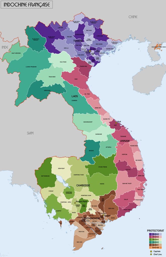
Français : Carte administrative de l'Indochine Francaise en 1937. Dans la carte des protectorats et provinces/districts sont montres. La source de donnees: AMS 509 (Indochina & Thailand) 1:250k (PCL Map collection). Reseau Routier de l'Indochine 1:2m (BNF). |
| Date | |
| Source | Own work |
| Author | XrysD |
| Other versions | Derivative works of this file: French Indochina 1937.png |
Licensing
I, the copyright holder of this work, hereby publish it under the following license:
This file is licensed under the Creative Commons Attribution-Share Alike 4.0 International license.
- You are free:
- to share – to copy, distribute and transmit the work
- to remix – to adapt the work
- Under the following conditions:
- attribution – You must give appropriate credit, provide a link to the license, and indicate if changes were made. You may do so in any reasonable manner, but not in any way that suggests the licensor endorses you or your use.
- share alike – If you remix, transform, or build upon the material, you must distribute your contributions under the same or compatible license as the original.
歷史集信
扨𠓨𣈜/𣇞抵䀡內容集信在時點妬。
| 𣈜/𣇞 | 形䀡𠓀 | 戟櫸 | 成員 | 描寫 | |
|---|---|---|---|---|---|
| 現在 | 15:44、𣈜29𣎃8𢆥2022 | | 1.292×2.000 (516kB) | wikimediacommons>XrysD | Nouvelles couleurs, île de Phú Quốc à Hatien en Cochinchine. |
張使用集信
張𢖖󠄁使用集信尼: